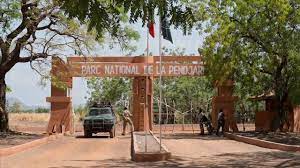
The Pendjari Park is part of the largest protected area in West Africa, in the same geographical area as the W National Park. The Park alone covers 480,000 hectares. Designated a biosphere reserve since 1986, the Park hosts an extremely rich ecosystem.
The Pendjari Biosphere Reserve (PBR) is part of the largest protected area complex in West Africa, the WAP (W-Arly-Pendjari) complex, which also includes the W (Benin-Niger-Burkina Faso) Transboundary Biosphere Reserve, and several protected areas of varying status in Burkina Faso (Pama Partial Reserve, Arly Total Wildlife Reserve, Singou Reserve) and Togo (Kéran National Park, Oti-Mandouri Wildlife Reserve), with a total area of about 50,000 km.
The PBR covers about 5,000 km2 , or 10% of the total. Its geographical limits are between 10°30' and 11°30' North latitude and 0°50' and 2°00' East longitude. From Cotonou, by road, the park is accessible through the forest posts of Porga or Batia (about 730 km), from Ouagadougou (Burkina-Faso) through the Arly bridge (527 km) - which connects it to the Arly Total Wildlife Reserve -, or from Niamey (Niger) through Kandi and Founougo (290 km)8 .
The reserve is well-watered, with average annual rainfall comparable to that in southern Benin, in the range of 1,000 to 1,100 m. The rainy season extends from mid-May to October. A dry and cool season, marked by the harmattan, follows from November to February, itself followed by a dry and hot season from March to mid-May, with temperatures that can reach 40 °C.
The reserve is established on a peneplain with flat relief whose altitude varies from 105 m to 200 m. This peneplain is formed of sandstone and shale, which makes it impermeable. The plain is bordered to the south by the Atacora mountain range made up of quartzite and whose altitude varies from 400 m to 513 m. Its northern and eastern borders are occupied by the Pendjari River. A second chain, the Buem, smaller and parallel to the first, is located within the Park. Due to its impermeability, the peneplain is either flooded in the rainy season or still waterlogged (CENAGREF, 2009).


